Geolocate

Creußen topographic map

Interactive map

Click on the map to display elevation.

About this map

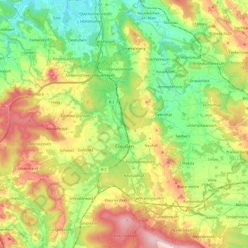
Name: Creußen topographic map, elevation, terrain.

Location: Creußen, Creußen (VGem), Landkreis Bayreuth, Bavaria, 95473, Germany (49.80954 11.49954 49.90461 11.73114)

Average elevation: 467 m

Minimum elevation: 344 m

Maximum elevation: 648 m

Other topographic maps

Click on a map to view its topography, its elevation and its terrain.

Pfarrhügel

Germany > Bavaria > Landkreis Bayreuth > Eckersdorf

Average elevation: 507 m

Reizendorf

Germany > Bavaria > Landkreis Bayreuth > Ahorntal

Average elevation: 435 m

Meinberg

Germany > Bavaria > Landkreis Bayreuth > Goldkronach

Average elevation: 450 m

Gottelhof

Germany > Bavaria > Landkreis Bayreuth > Hollfeld

Average elevation: 407 m

Röhrig

Germany > Bavaria > Landkreis Bayreuth > Bindlacher Berg

Average elevation: 410 m