
Lake Leelanau topographic map
Interactive map
Click on the map to display elevation.
About this map
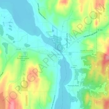
Name: Lake Leelanau topographic map, elevation, terrain.
Average elevation: 210 m
Minimum elevation: 175 m
Maximum elevation: 280 m
Other topographic maps
Click on a map to view its topography, its elevation and its terrain.
South Fox Island
United States > Michigan > Leelanau County
North Fox Island has an operational public 3,001-foot-long by 100-foot-wide (914m x 30m) grass airstrip as of August 2023, making it accessible by general aviation. Runway 7 has a displaced threshold of 804 ft. and Runway 25 has a displaced threshold of 999 ft. Both runways have trees at their ends ranging…
Average elevation: 185 m
Sleeping Bear Dunes National Lakeshore
United States > Michigan > Leelanau County
Average elevation: 204 m