Yên Thủy District topographic map
Interactive map
Click on the map to display elevation.
About this map
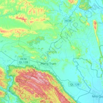
Name: Yên Thủy District topographic map, elevation, terrain.
Location: Yên Thủy District, Hoà Bình province, Vietnam (20.30536 105.53987 20.54967 105.72957)
Average elevation: 125 m
Minimum elevation: 1 m
Maximum elevation: 607 m
Other topographic maps
Click on a map to view its topography, its elevation and its terrain.
Hòa Bình City
Hòa Bình City, Hoà Bình province, Vietnam
Average elevation: 202 m
Kim Bôi District
Vietnam > Hoa Binh province > Kim Bôi District
Kim Bôi District, Hoà Bình province, Vietnam
Average elevation: 260 m
Kỳ Sơn District
Kỳ Sơn District, Hoà Bình province, 351541, Vietnam
Average elevation: 161 m
Cao Phong District
Cao Phong District, Hoà Bình province, Vietnam
Average elevation: 330 m
Mai Châu District
Mai Châu District, Hoa Binh province, Vietnam
Average elevation: 559 m
Phương Lâm
Vietnam > Hoa Binh province > Hòa Bình City > Phương Lâm
Phương Lâm, Hòa Bình City, Hoa Binh province, Vietnam
Average elevation: 136 m