
Thank you for supporting this site ❤️
Make a donation
Make a donation
Gear up for your next adventure:
As an Amazon Associate, this site earns from qualifying purchases at no extra cost to you.
Kaathene topographic map
Click on the map to display elevation.
Thank you for supporting this site ❤️
Make a donation
Make a donation
Gear up for your next adventure:
As an Amazon Associate, this site earns from qualifying purchases at no extra cost to you.
About this map
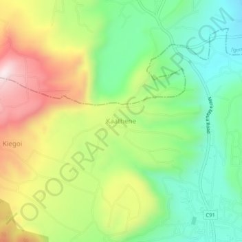
Name: Kaathene topographic map, elevation, terrain.
Location: Kaathene, Igembe South, Meru County, Eastern, Kenya (0.22870 37.90588 0.26870 37.94588)
Average elevation: 1,797 m
Minimum elevation: 1,546 m
Maximum elevation: 2,169 m
Thank you for supporting this site ❤️
Make a donation
Make a donation
Gear up for your next adventure:
As an Amazon Associate, this site earns from qualifying purchases at no extra cost to you.