
Waischenfeld topographic map
Interactive map
Click on the map to display elevation.
About this map
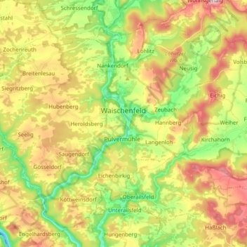
Name: Waischenfeld topographic map, elevation, terrain.
Location: Waischenfeld, Landkreis Bayreuth, Bavaria, 91344, Germany (49.79969 11.25670 49.88290 11.40954)
Average elevation: 435 m
Minimum elevation: 309 m
Maximum elevation: 580 m
Other topographic maps
Click on a map to view its topography, its elevation and its terrain.
95469
Germany > Bavaria > Landkreis Bayreuth > Kirchenlaibach
95469, Kirchenlaibach, Speichersdorf, Landkreis Bayreuth, Bavaria, Germany
Average elevation: 464 m
Görschnitz
Germany > Bavaria > Landkreis Bayreuth > Weidenberg
Görschnitz, Weidenberg, Weidenberg (VGem), Landkreis Bayreuth, Bavaria, 95466, Germany
Average elevation: 486 m
Pegnitz
Germany > Bavaria > Landkreis Bayreuth
Pegnitz, Landkreis Bayreuth, Bavaria, 91257, Germany
Average elevation: 485 m
Gefrees
Germany > Bavaria > Landkreis Bayreuth
Gefrees, Landkreis Bayreuth, Bavaria, 95482, Germany
Average elevation: 585 m