
Make a donation
Gear up for your next adventure:
As an Amazon Associate, this site earns from qualifying purchases at no extra cost to you.
Holland topographic map
Click on the map to display elevation.
Make a donation
Gear up for your next adventure:
As an Amazon Associate, this site earns from qualifying purchases at no extra cost to you.
About this map
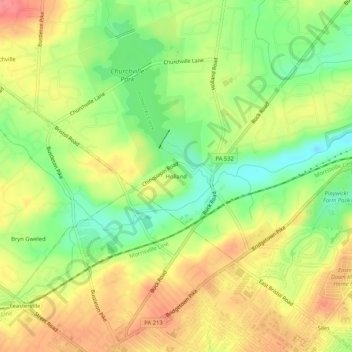
Name: Holland topographic map, elevation, terrain.
Average elevation: 53 m
Minimum elevation: 15 m
Maximum elevation: 89 m
Make a donation
Gear up for your next adventure:
As an Amazon Associate, this site earns from qualifying purchases at no extra cost to you.
Other topographic maps
Click on a map to view its topography, its elevation and its terrain.
Tyler State Park
United States > Pennsylvania > Bucks County > Northampton Township
Average elevation: 67 m
Churchville
United States > Pennsylvania > Bucks County > Northampton Township > Richboro
Average elevation: 63 m
Richboro
United States > Pennsylvania > Bucks County > Northampton Township > Richboro
Average elevation: 79 m