
Thank you for supporting this site ❤️
Make a donation
Make a donation
Gear up for your next adventure:
As an Amazon Associate, this site earns from qualifying purchases at no extra cost to you.
Changmai topographic map
Click on the map to display elevation.
Thank you for supporting this site ❤️
Make a donation
Make a donation
Gear up for your next adventure:
As an Amazon Associate, this site earns from qualifying purchases at no extra cost to you.
About this map
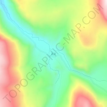
Name: Changmai topographic map, elevation, terrain.
Location: Changmai, Baiyü County, Kardze, Sichuan, 627100, China (31.21589 99.65239 31.25589 99.69239)
Average elevation: 4,248 m
Minimum elevation: 3,971 m
Maximum elevation: 4,619 m
Thank you for supporting this site ❤️
Make a donation
Make a donation
Gear up for your next adventure:
As an Amazon Associate, this site earns from qualifying purchases at no extra cost to you.