
Make a donation
Gear up for your next adventure:
As an Amazon Associate, this site earns from qualifying purchases at no extra cost to you.
Arlington topographic map
Click on the map to display elevation.
Make a donation
Gear up for your next adventure:
As an Amazon Associate, this site earns from qualifying purchases at no extra cost to you.
About this map
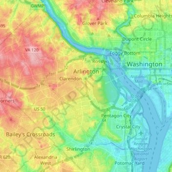
Name: Arlington topographic map, elevation, terrain.
Location: Arlington, Arlington County, Virginia, United States (38.82747 -77.17228 38.93435 -77.03100)
Average elevation: 51 m
Minimum elevation: -3 m
Maximum elevation: 132 m
Make a donation
Gear up for your next adventure:
As an Amazon Associate, this site earns from qualifying purchases at no extra cost to you.
Other topographic maps
Click on a map to view its topography, its elevation and its terrain.
Fort Meyer Heights Park
United States > Virginia > Arlington County > Arlington
Average elevation: 39 m
Radnor Heights
United States > Virginia > Arlington County > Arlington > Radnor Heights
Average elevation: 36 m