
Make a donation
Gear up for your next adventure:
As an Amazon Associate, this site earns from qualifying purchases at no extra cost to you.
Le Change topographic map
Click on the map to display elevation.
Make a donation
Gear up for your next adventure:
As an Amazon Associate, this site earns from qualifying purchases at no extra cost to you.
Le Change
L'altitude minimale, 92 mètres, se trouve près du lieu-dit la Roquette, là où l'Auvézère quitte la commune pour servir de limite entre celles de Bassillac et d'Eyliac. L'altitude maximale avec 228 mètres est localisée au sud, au "lac Ouyaud", en limite de la commune de Blis-et-Born.
Make a donation
Gear up for your next adventure:
As an Amazon Associate, this site earns from qualifying purchases at no extra cost to you.
About this map
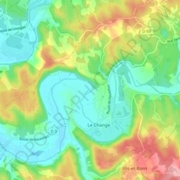
Name: Le Change topographic map, elevation, terrain.
Average elevation: 151 m
Minimum elevation: 94 m
Maximum elevation: 256 m
Make a donation
Gear up for your next adventure:
As an Amazon Associate, this site earns from qualifying purchases at no extra cost to you.