
Aegina topographic map
Interactive map
Click on the map to display elevation.
About this map
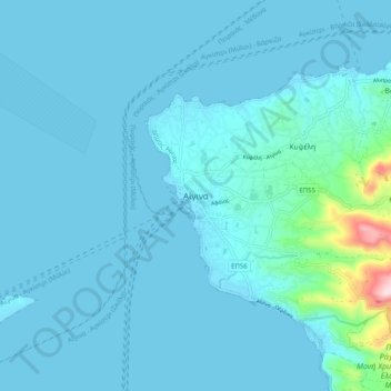
Name: Aegina topographic map, elevation, terrain.
Average elevation: 27 m
Minimum elevation: -2 m
Maximum elevation: 365 m
Other topographic maps
Click on a map to view its topography, its elevation and its terrain.
Ευαγγελίστριας
Greece > Attica > Regional Unit of Islands > Salamina Municipal Unit > Σατερλί
Average elevation: 23 m
Methana
Greece > Attica > Regional Unit of Islands > Municipal Unit of Methana
Since 1991, the peninsula has been investigated by the team of ETH Zürich geologically and cartographically. From this, a topographical map of the entire peninsula at a scale of 1:25,000 was made. An interactive 3D map was created and is on the World Wide Web. Also a rich photographic archive with about…
Average elevation: 123 m
Poros
Greece > Attica > Regional Unit of Islands > Poros
The land area of the municipality (which includes the islands and part of the adjacent Peloponnese coast) is 49.582 square kilometres (19.144 sq mi). The landscape is very hilly and mountainous. The highest peak is the Vigla (358 m) in the west-central part. Following the island's topography and geology, small…
Average elevation: 31 m
Antikythera
Greece > Attica > Regional Unit of Islands > Municipal Unit of Antikythira
Average elevation: 30 m