Geolocate

Aßlar topographic map

Interactive map

Click on the map to display elevation.

About this map

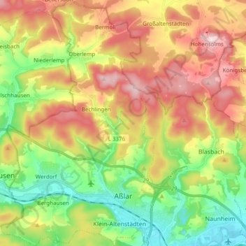
Name: Aßlar topographic map, elevation, terrain.

Location: Aßlar, Lahn-Dill-Kreis, Hesse, 35614, Germany (50.57331 8.38978 50.66916 8.48469)

Average elevation: 280 m

Minimum elevation: 147 m

Maximum elevation: 440 m

Other topographic maps

Click on a map to view its topography, its elevation and its terrain.

Kraftsolms

Germany > Hesse > Lahn-Dill-Kreis

Kraftsolms, Waldsolms, Lahn-Dill-Kreis, Hesse, Germany

Average elevation: 280 m

Offdilln

Germany > Hesse > Lahn-Dill-Kreis > Haiger

Offdilln, Haiger, Lahn-Dill-Kreis, Hesse, Germany

Average elevation: 492 m

Haiger

Germany > Hesse > Lahn-Dill-Kreis

Haiger, Lahn-Dill-Kreis, Hesse, 35708, Germany

Average elevation: 409 m

Greifenstein

Germany > Hesse > Lahn-Dill-Kreis

Greifenstein, Lahn-Dill-Kreis, Hesse, 35753, Germany

Average elevation: 345 m

Braunfels

Germany > Hesse > Lahn-Dill-Kreis

Braunfels, Lahn-Dill-Kreis, Hesse, Germany

Average elevation: 242 m