Geolocate

Laneia topographic map

Click on the map to display elevation.

About this map

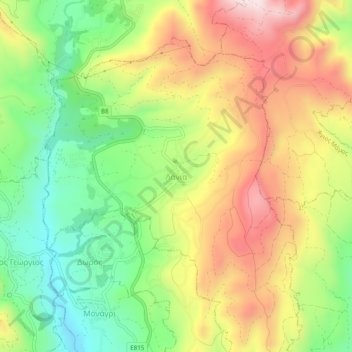
Name: Laneia topographic map, elevation, terrain.

Location: Laneia, Limassol District, Cyprus, 4730, Cyprus (34.80491 32.90109 34.84491 32.94109)

Average elevation: 604 m

Minimum elevation: 364 m

Maximum elevation: 882 m

Gear up for your next adventure:

🧺Ultralight Dry Bags - Organize and waterproof your gear inside your rucksack
🧢Hiking Hats - Sun and weather protection for outdoor walks
🥫Expedition Meals - Lightweight, high-calorie nutrition for long-distance hikers
🥾Men's Waterproof Hiking Boots - Durable footwear with deep lugs for muddy and rocky UK terrains
📢Survival Whistles - Essential safety gear for signaling for help in mountain fog

As an Amazon Associate, this site earns from qualifying purchases at no extra cost to you.