
Berlin topographic map
Interactive map
Click on the map to display elevation.
About this map
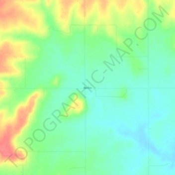
Name: Berlin topographic map, elevation, terrain.
Location: Berlin, Bourbon County, Kansas, United States (37.90143 -94.91608 37.94143 -94.87608)
Average elevation: 293 m
Minimum elevation: 268 m
Maximum elevation: 336 m
Other topographic maps
Click on a map to view its topography, its elevation and its terrain.
Garland
United States > Kansas > Bourbon County
Garland, Bourbon County, Kansas, 66741, United States
Average elevation: 259 m
Redfield
United States > Kansas > Bourbon County
Redfield, Bourbon County, Kansas, United States
Average elevation: 263 m
Hammond
United States > Kansas > Bourbon County
Hammond, Bourbon County, Kansas, United States
Average elevation: 266 m
Marmaton
United States > Kansas > Bourbon County
Marmaton, Bourbon County, Kansas, United States
Average elevation: 266 m
Mapleton
United States > Kansas > Bourbon County
Mapleton, Bourbon County, Kansas, United States
Average elevation: 267 m
Devon
United States > Kansas > Bourbon County
Devon, Bourbon County, Kansas, United States
Average elevation: 268 m
Harding
United States > Kansas > Bourbon County
Harding, Bourbon County, Kansas, 66764, United States
Average elevation: 267 m
Pawnee Station
United States > Kansas > Bourbon County
Pawnee Station, Bourbon County, Kansas, United States
Average elevation: 296 m
Xenia
United States > Kansas > Bourbon County
Xenia, Bourbon County, Kansas, United States
Average elevation: 295 m
Bronson
United States > Kansas > Bourbon County
Bronson, Bourbon County, Kansas, United States
Average elevation: 323 m
Fulton
United States > Kansas > Bourbon County
Fulton, Bourbon County, Kansas, 66738, United States
Average elevation: 252 m
Barnesville
United States > Kansas > Bourbon County
Barnesville, Bourbon County, Kansas, United States
Average elevation: 252 m
Godfrey
United States > Kansas > Bourbon County
Godfrey, Bourbon County, Kansas, United States
Average elevation: 287 m
Hiattville
United States > Kansas > Bourbon County
Hiattville, Bourbon County, Kansas, United States
Average elevation: 293 m
Porterville
United States > Kansas > Bourbon County
Porterville, Bourbon County, Kansas, United States
Average elevation: 317 m
Fort Scott
United States > Kansas > Bourbon County
Fort Scott, Bourbon County, Kansas, 66701, United States
Average elevation: 266 m
Uniontown
United States > Kansas > Bourbon County
Uniontown, Bourbon County, Kansas, United States
Average elevation: 275 m