
Thank you for supporting this site ❤️
Make a donation
Make a donation
Gear up for your next adventure:
As an Amazon Associate, this site earns from qualifying purchases at no extra cost to you.
Šolta topographic map
Click on the map to display elevation.
Thank you for supporting this site ❤️
Make a donation
Make a donation
Gear up for your next adventure:
As an Amazon Associate, this site earns from qualifying purchases at no extra cost to you.
About this map
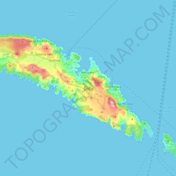
Name: Šolta topographic map, elevation, terrain.
Location: Šolta, Nečujam, Općina Šolta, Split-Dalmatia County, Croatia (43.32458 16.20024 43.41448 16.39930)
Average elevation: 19 m
Minimum elevation: -2 m
Maximum elevation: 232 m
Thank you for supporting this site ❤️
Make a donation
Make a donation
Gear up for your next adventure:
As an Amazon Associate, this site earns from qualifying purchases at no extra cost to you.