
Make a donation
Gear up for your next adventure:
As an Amazon Associate, this site earns from qualifying purchases at no extra cost to you.
Villalobos topographic map
Click on the map to display elevation.
Make a donation
Gear up for your next adventure:
As an Amazon Associate, this site earns from qualifying purchases at no extra cost to you.
Villalobos
Se encuentra una altitud de unos 880 m sobre el nivel del mar, aunque tiene otros parajes con mayor altura, como son El Cerro del Tablero, a 991 m, El Veneroso, a 1068 m y El Camello a 1204 m.
Make a donation
Gear up for your next adventure:
As an Amazon Associate, this site earns from qualifying purchases at no extra cost to you.
About this map
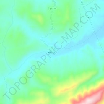
Name: Villalobos topographic map, elevation, terrain.
Location: Villalobos, Alcalá la Real, Jaén, Andalucía, 23688, España (37.38931 -3.93336 37.42931 -3.89336)
Average elevation: 916 m
Minimum elevation: 827 m
Maximum elevation: 1,207 m
Make a donation
Gear up for your next adventure:
As an Amazon Associate, this site earns from qualifying purchases at no extra cost to you.