
Jeebel topographic map
Interactive map
Click on the map to display elevation.
About this map
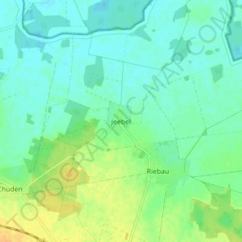
Name: Jeebel topographic map, elevation, terrain.
Average elevation: 26 m
Minimum elevation: 17 m
Maximum elevation: 44 m
Other topographic maps
Click on a map to view its topography, its elevation and its terrain.
Klein Chüden
Deutschland > Sachsen-Anhalt > Altmarkkreis Salzwedel > Salzwedel
Klein Chüden, Salzwedel, Altmarkkreis Salzwedel, Sachsen-Anhalt, 29488, Deutschland
Average elevation: 22 m
Darsekau
Deutschland > Sachsen-Anhalt > Altmarkkreis Salzwedel > Salzwedel
Darsekau, Salzwedel, Altmarkkreis Salzwedel, Sachsen-Anhalt, 29487, Deutschland
Average elevation: 29 m
Benkendorf
Deutschland > Sachsen-Anhalt > Altmarkkreis Salzwedel > Salzwedel > Benkendorf
Benkendorf, Salzwedel, Altmarkkreis Salzwedel, Sachsen-Anhalt, Deutschland
Average elevation: 42 m