
Thank you for supporting this site ❤️
Make a donation
Make a donation
Gear up for your next adventure:
As an Amazon Associate, this site earns from qualifying purchases at no extra cost to you.
Huanuquillo topographic map
Click on the map to display elevation.
Thank you for supporting this site ❤️
Make a donation
Make a donation
Gear up for your next adventure:
As an Amazon Associate, this site earns from qualifying purchases at no extra cost to you.
About this map
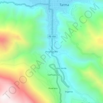
Name: Huanuquillo topographic map, elevation, terrain.
Location: Huanuquillo, Tarma, Junín, 12651, Perú (-11.45814 -75.71274 -11.41814 -75.67274)
Average elevation: 3,413 m
Minimum elevation: 3,049 m
Maximum elevation: 4,197 m
Thank you for supporting this site ❤️
Make a donation
Make a donation
Gear up for your next adventure:
As an Amazon Associate, this site earns from qualifying purchases at no extra cost to you.