
Lac de Remoray topographic map
Interactive map
Click on the map to display elevation.
About this map
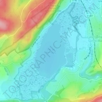
Name: Lac de Remoray topographic map, elevation, terrain.
Average elevation: 887 m
Minimum elevation: 847 m
Maximum elevation: 996 m
Other topographic maps
Click on a map to view its topography, its elevation and its terrain.
Granges-Sainte-Marie
France > Bourgogne-Franche-Comté > Doubs > Labergement-Sainte-Marie
Granges-Sainte-Marie, Labergement-Sainte-Marie, Pontarlier, Doubs, Bourgogne-Franche-Comté, France métropolitaine, 25160, France
Average elevation: 908 m