
Make a donation
Gear up for your next adventure:
As an Amazon Associate, this site earns from qualifying purchases at no extra cost to you.
Mistrató topographic map
Click on the map to display elevation.
Make a donation
Gear up for your next adventure:
As an Amazon Associate, this site earns from qualifying purchases at no extra cost to you.
Mistrató
Mistrato (elevation 1900 m) is a town and municipality in the Department of Risaralda, Colombia. The town is located about two hours west of Pereira.
Make a donation
Gear up for your next adventure:
As an Amazon Associate, this site earns from qualifying purchases at no extra cost to you.
About this map
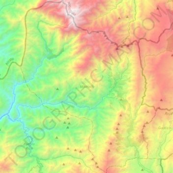
Name: Mistrató topographic map, elevation, terrain.
Location: Mistrató, Vertiente Pacífico, Risaralda, Colombia (5.24472 -76.08698 5.56804 -75.83301)
Average elevation: 1,725 m
Minimum elevation: 400 m
Maximum elevation: 3,776 m
Make a donation
Gear up for your next adventure:
As an Amazon Associate, this site earns from qualifying purchases at no extra cost to you.
Other topographic maps
Click on a map to view its topography, its elevation and its terrain.
Make a donation
Gear up for your next adventure:
As an Amazon Associate, this site earns from qualifying purchases at no extra cost to you.