
Pilsting topographic map
Interactive map
Click on the map to display elevation.
About this map
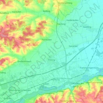
Name: Pilsting topographic map, elevation, terrain.
Location: Pilsting, Landkreis Dingolfing-Landau, Bavaria, 94431, Germany (48.66280 12.53777 48.75828 12.71473)
Average elevation: 362 m
Minimum elevation: 329 m
Maximum elevation: 448 m
Other topographic maps
Click on a map to view its topography, its elevation and its terrain.
Oberdaching
Germany > Bavaria > Landkreis Dingolfing-Landau > Pilsting
Oberdaching, Pilsting, Landkreis Dingolfing-Landau, Bavaria, Germany
Average elevation: 399 m
Hartkirchen
Germany > Bavaria > Landkreis Dingolfing-Landau
Hartkirchen, Eichendorf, Landkreis Dingolfing-Landau, Bavaria, 94574, Germany
Average elevation: 376 m
Reisbach
Germany > Bavaria > Landkreis Dingolfing-Landau
Reisbach, Landkreis Dingolfing-Landau, Bavaria, 94419, Germany
Average elevation: 443 m
Dingolfing
Germany > Bavaria > Landkreis Dingolfing-Landau
Dingolfing, Landkreis Dingolfing-Landau, Bavaria, 84130, Germany
Average elevation: 418 m