
Reserva Nacional Mocho Choshuenco topographic map
Interactive map
Click on the map to display elevation.
About this map
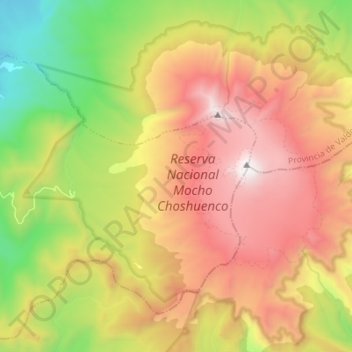
Name: Reserva Nacional Mocho Choshuenco topographic map, elevation, terrain.
Average elevation: 1,325 m
Minimum elevation: 274 m
Maximum elevation: 2,415 m
Other topographic maps
Click on a map to view its topography, its elevation and its terrain.
Lago Riñihue
Chile > Región de Los Ríos > Los Lagos
Lago Riñihue, Cruce Ruta 203 CH (Choshuenco) - Enco - Riñihue - Cruce T-39 (Quinchilca), Los Lagos, Provincia de Valdivia, Región de Los Ríos, Chile
Average elevation: 612 m