
Kings Peak topographic map
Interactive map
Click on the map to display elevation.
About this map
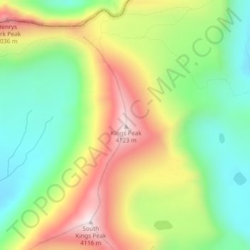
Name: Kings Peak topographic map, elevation, terrain.
Location: Kings Peak, Duchesne County, Utah, United States (40.77619 -110.37285 40.77629 -110.37275)
Average elevation: 3,743 m
Minimum elevation: 3,469 m
Maximum elevation: 4,118 m
Other topographic maps
Click on a map to view its topography, its elevation and its terrain.
Fruitland
United States > Utah > Duchesne County
Fruitland, Duchesne County, Utah, 84027, United States
Average elevation: 2,028 m