
Saint Andrew topographic map
Interactive map
Click on the map to display elevation.
Saint Andrew
San Andrés is the largest of the island group in the Department of the Archipelago of San Andrés, Providence and Saint Catherine. San Andrés is located in the Caribbean Sea, about 750 km (470 mi) northwest of the coast of Colombia. The island is 13 km (8.1 mi) in length and 3 km (1.9 mi) in width. It has an area of 26 km2 (10 sq mi) within the total area of the group of islands of 45 square kilometres (17 sq mi) (27 km2 (10 sq mi) is also mentioned in this reference for San Andrés), making it the largest island in the archipelago. Providencia, the next largest in area, is located 80 km (50 mi) to the northeast. San Andrés has a fairly flat topography with the highest point in the island reported at an elevation of 55 m (180 ft) above sea level. San Andrés is crossed from south to north by a small mountain range whose highest peak is Cerro La Loma, also known as El Cliff. San Andrés' soils indicate that their formation is due to the eruption of a volcano which threw rocks older than the seafloor to the surface, creating the islands. Despite this, there is fertile soil and the soil is mostly red clay. It is easy to find small deposits of quartz on the island, especially in the neighborhood of La Loma Cove. Aside from the main settlements, the island is almost entirely covered in grass, trees and other vegetation, as well as sand along the coastline rather than rocks. The central area is marked by a chain of hills (Flowers, Orange, Shingle and Lion's Hill). The island has only small, ephemeral streams draining the land area, but no major rivers.
About this map
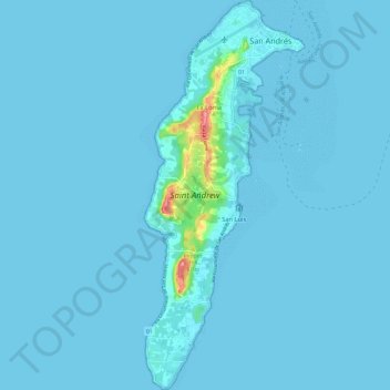
Name: Saint Andrew topographic map, elevation, terrain.
Location: Saint Andrew, San Luis, San Andrés and Providencia, Colombia (12.48029 -81.73566 12.59491 -81.68728)
Average elevation: 3 m
Minimum elevation: -1 m
Maximum elevation: 91 m