
Lesbos topographic map
Interactive map
Click on the map to display elevation.
About this map
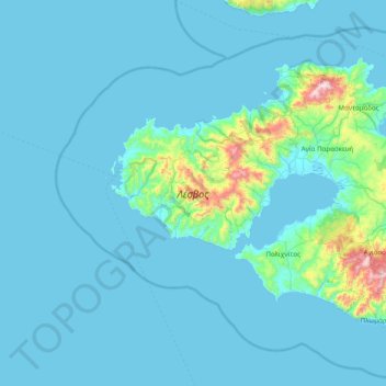
Name: Lesbos topographic map, elevation, terrain.
Location: Lesbos, Aegean, Greece (38.96158 25.83165 39.39015 26.61597)
Average elevation: 64 m
Minimum elevation: 0 m
Maximum elevation: 928 m
Other topographic maps
Click on a map to view its topography, its elevation and its terrain.
Varella
Greece > Aegean > Samos Regional Unit > Municipal Unit of Vathy > Vathy
Average elevation: 146 m
Kolona
Greece > Aegean > Samos Regional Unit > Municipal Unit of Pythagoreio > Ireo
Average elevation: 30 m
Balos Beach
Greece > Aegean > Samos Regional Unit > Municipal Unit of Marathokabos > Koumeika > Ormos Koumeikon
Average elevation: 66 m
Oia
Greece > Aegean > Thira Regional Unit > Ia Municipal Unit
The village is located on top of a hill, at about 150 m (500 ft) elevation, and known as the "Eagles nest" from where Palia and Nea Kameni volcanoes are seen and also the island of Therasia. It is situated to the north of the island and Fira is at distance of 11 km (7 mi). The main street in the town, in the…
Average elevation: 20 m
Φιλότι
Greece > Aegean > Naxos Regional Unit
Filoti (in Greek: Φιλώτι or Φιλότι; officially: Φιλότιον) is a semi-mountainous village of central Naxos, Greece, with a population of 1,477 residents (census 2011), located at the foot of Mt. Zas (1,004 m), at an altitude of 400 meters, about 18.2 kilometres (11.3 mi) from the city of…
Average elevation: 482 m