
Forel-sur-Lucens topographic map
Interactive map
Click on the map to display elevation.
About this map
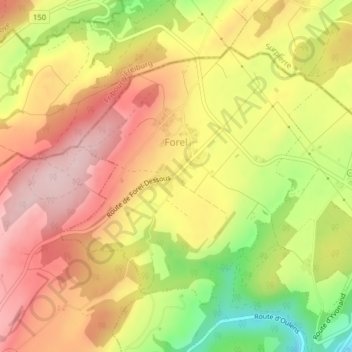
Name: Forel-sur-Lucens topographic map, elevation, terrain.
Average elevation: 672 m
Minimum elevation: 516 m
Maximum elevation: 785 m
Other topographic maps
Click on a map to view its topography, its elevation and its terrain.
La Broye
Switzerland > Vaud > District de la Broye-Vully
La Broye, District de la Broye-Vully, Vaud, 1530, Switzerland
Average elevation: 735 m
Payerne
Switzerland > Vaud > District de la Broye-Vully > Payerne
Payerne, District de la Broye-Vully, Vaud, Switzerland
Average elevation: 495 m