
Make a donation
Gear up for your next adventure:
As an Amazon Associate, this site earns from qualifying purchases at no extra cost to you.
Deming topographic map
Click on the map to display elevation.
Make a donation
Gear up for your next adventure:
As an Amazon Associate, this site earns from qualifying purchases at no extra cost to you.
Deming
Deming is located within the Upper Chihuahuan Desert climate zone. The climate is dry, hot, and breezy. Summer temperatures often exceed 100 °F (38 °C), but the altitude (4,300 feet (1,300 m)) and dry air sometimes make summer days more comfortable than one would expect given the high temperature.
Make a donation
Gear up for your next adventure:
As an Amazon Associate, this site earns from qualifying purchases at no extra cost to you.
About this map
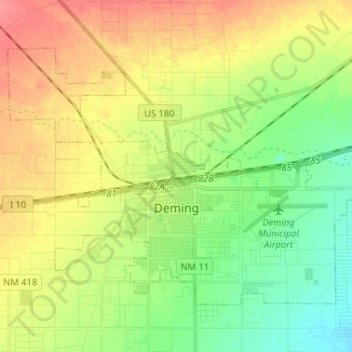
Name: Deming topographic map, elevation, terrain.
Location: Deming, Luna County, New Mexico, 88030, United States (32.23243 -107.82053 32.31250 -107.69091)
Average elevation: 1,327 m
Minimum elevation: 1,300 m
Maximum elevation: 1,358 m
Make a donation
Gear up for your next adventure:
As an Amazon Associate, this site earns from qualifying purchases at no extra cost to you.
Other topographic maps
Click on a map to view its topography, its elevation and its terrain.