
Make a donation
Gear up for your next adventure:
As an Amazon Associate, this site earns from qualifying purchases at no extra cost to you.
Castle Rock topographic map
Click on the map to display elevation.
Make a donation
Gear up for your next adventure:
As an Amazon Associate, this site earns from qualifying purchases at no extra cost to you.
About this map
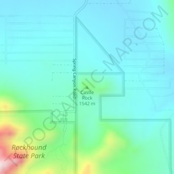
Name: Castle Rock topographic map, elevation, terrain.
Location: Castle Rock, Luna County, New Mexico, United States (32.15643 -107.61369 32.15653 -107.61359)
Average elevation: 1,466 m
Minimum elevation: 1,376 m
Maximum elevation: 1,866 m
Make a donation
Gear up for your next adventure:
As an Amazon Associate, this site earns from qualifying purchases at no extra cost to you.
Other topographic maps
Click on a map to view its topography, its elevation and its terrain.
Deming
United States > New Mexico > Luna County
Deming is located within the Upper Chihuahuan Desert climate zone. The climate is dry, hot, and breezy. Summer temperatures often exceed 100 °F (38 °C), but the altitude (4,300 feet (1,300 m)) and dry air sometimes make summer days more comfortable than one would expect given the high temperature.
Average elevation: 1,327 m