
Make a donation
Gear up for your next adventure:
As an Amazon Associate, this site earns from qualifying purchases at no extra cost to you.
Almudévar topographic map
Click on the map to display elevation.
Make a donation
Gear up for your next adventure:
As an Amazon Associate, this site earns from qualifying purchases at no extra cost to you.
Almudévar
The relief of the municipality is predominantly flat, and includes part of the Llanos de la Violada. The altitude oscillates between 603 meters north (Saso Plano) and 390 meters south. The town is 456 m above sea level.
Make a donation
Gear up for your next adventure:
As an Amazon Associate, this site earns from qualifying purchases at no extra cost to you.
About this map
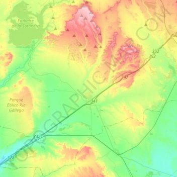
Name: Almudévar topographic map, elevation, terrain.
Average elevation: 429 m
Minimum elevation: 329 m
Maximum elevation: 604 m
Make a donation
Gear up for your next adventure:
As an Amazon Associate, this site earns from qualifying purchases at no extra cost to you.
Other topographic maps
Click on a map to view its topography, its elevation and its terrain.
Marcuello
Spain > Aragon > Hoya de Huesca / Plana de Uesca > Loarre > Linás de Marcuello
Average elevation: 863 m
Vitales
Spain > Aragon > Hoya de Huesca / Plana de Uesca > Monflorite-Lascasas
Average elevation: 492 m
Make a donation
Gear up for your next adventure:
As an Amazon Associate, this site earns from qualifying purchases at no extra cost to you.
Riglos
Spain > Aragon > Hoya de Huesca / Plana de Uesca > Las Peñas de Riglos
Average elevation: 726 m