
Great Sand Dunes National Preserve topographic map
Interactive map
Click on the map to display elevation.
About this map
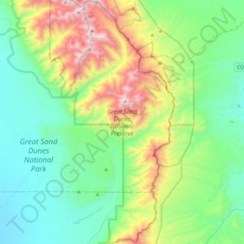
Name: Great Sand Dunes National Preserve topographic map, elevation, terrain.
Average elevation: 2,792 m
Minimum elevation: 2,308 m
Maximum elevation: 4,128 m
In 1848, John C. Frémont was hired to find a railroad route from St. Louis to California. He crossed the Sangre de Cristos into the San Luis Valley in winter, courting disaster but proving that a winter crossing of this range was possible. He was followed in 1853 by Captain John Gunnison of the Corps of Topographical Engineers. Gunnison's party crossed the dunefield on horseback.[11]
Other topographic maps
Click on a map to view its topography, its elevation and its terrain.
La Garita
United States > Colorado > Saguache County
La Garita, Saguache County, Colorado, United States
Average elevation: 2,384 m
Twin Mountains
United States > Colorado > Saguache County
Twin Mountains, Saguache County, Colorado, United States
Average elevation: 2,919 m
Challenger Point
United States > Colorado > Saguache County
Challenger Point, Saguache County, Colorado, United States
Average elevation: 3,781 m
Crestone
United States > Colorado > Saguache County
Crestone, Saguache County, Colorado, United States
Average elevation: 2,444 m
Great Sand Dunes National Park
United States > Colorado > Saguache County
Great Sand Dunes National Park, Saguache County, Colorado, United States
Average elevation: 2,616 m