
Blangkejeren topographic map
Interactive map
Click on the map to display elevation.
About this map
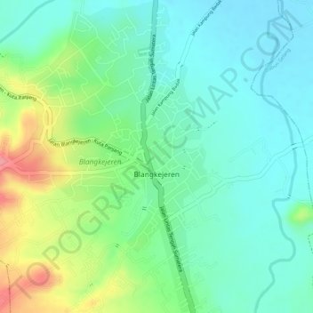
Name: Blangkejeren topographic map, elevation, terrain.
Location: Blangkejeren, Blang Kejeren, Gayo Lues, Aceh, Indonesia (3.98254 97.32608 4.00977 97.34659)
Average elevation: 920 m
Minimum elevation: 886 m
Maximum elevation: 991 m
Other topographic maps
Click on a map to view its topography, its elevation and its terrain.