
Lessona topographic map
Interactive map
Click on the map to display elevation.
About this map
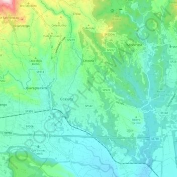
Name: Lessona topographic map, elevation, terrain.
Location: Lessona, Biella, Piedmont, 13853, Italy (45.53430 8.17455 45.61497 8.23936)
Average elevation: 294 m
Minimum elevation: 201 m
Maximum elevation: 644 m
Other topographic maps
Click on a map to view its topography, its elevation and its terrain.
Centro Zegna
Italy > Piedmont > Biella > Guala
Centro Zegna, Trivero, Guala, Valdilana, Biella, Piedmont, 13833, Italy
Average elevation: 798 m
Il Gorgomoro
Italy > Piedmont > Biella > Biella > Cossila San Grato
Il Gorgomoro, Cossila San Grato, Biella, Piedmont, 13818, Italy
Average elevation: 493 m
Malpensà
Italy > Piedmont > Biella > Campiglia Cervo
Malpensà, Campiglia Cervo, Biella, Piedmont, 13812, Italy
Average elevation: 1,099 m
San Giovanni
Italy > Piedmont > Biella > Campiglia Cervo
San Giovanni, Campiglia Cervo, Biella, Piedmont, 13815, Italy
Average elevation: 1,196 m
Borgata Brughiera
Italy > Piedmont > Biella > Bulliana
Borgata Brughiera, Mosso, Bulliana, Valdilana, Biella, Piedmont, 13835, Italy
Average elevation: 806 m