
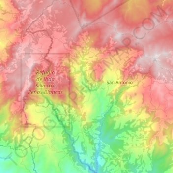
Zapotal topographic map
Interactive map
Click on the map to display elevation.
About this map
Name: Zapotal topographic map, elevation, terrain.
Average elevation: 1,008 m
Minimum elevation: 279 m
Maximum elevation: 1,596 m
Other topographic maps
Click on a map to view its topography, its elevation and its terrain.
Quebradillas
Costa Rica > Cantón San Ramón > Piedades Sur
Quebradillas, Piedades Sur, Cantón San Ramón, Alajuela Province, 20205, Costa Rica
Average elevation: 1,153 m
Río Jesús
Costa Rica > Cantón San Ramón > San Rafael > Berlín
Río Jesús, Berlín, San Rafael, Cantón San Ramón, Alajuela Province, 20206, Costa Rica
Average elevation: 1,246 m
Río Jesús
Costa Rica > Cantón San Ramón > Santiago
Río Jesús, Santiago, Cantón San Ramón, Alajuela Province, 20202, Costa Rica
Average elevation: 1,042 m
H6
Costa Rica > Cantón San Ramón > San Juan
H6, Residencial Los Lirios, San Juan, Cantón San Ramón, Alajuela Province, 20203, Costa Rica
Average elevation: 1,070 m