
Thank you for supporting this site ❤️
Make a donation
Make a donation
Gear up for your next adventure:
As an Amazon Associate, this site earns from qualifying purchases at no extra cost to you.
Nahliel topographic map
Click on the map to display elevation.
Thank you for supporting this site ❤️
Make a donation
Make a donation
Gear up for your next adventure:
As an Amazon Associate, this site earns from qualifying purchases at no extra cost to you.
About this map
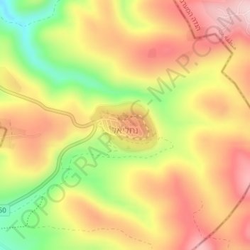
Name: Nahliel topographic map, elevation, terrain.
Location: Nahliel, Area C, Judea and Samaria, Palestinian Territories (31.97253 35.13660 31.97584 35.14353)
Average elevation: 543 m
Minimum elevation: 385 m
Maximum elevation: 661 m
Thank you for supporting this site ❤️
Make a donation
Make a donation
Gear up for your next adventure:
As an Amazon Associate, this site earns from qualifying purchases at no extra cost to you.
Other topographic maps
Click on a map to view its topography, its elevation and its terrain.
Wadi al Qilt
Palestinian Territories > Judea and Samaria > Area C > Ma'ale Adumim > Wadi al Qilt
Average elevation: 96 m