Geolocate

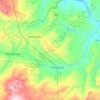
Mission topographic map

Click on the map to display elevation.

About this map

Name: Mission topographic map, elevation, terrain.

Location: Mission, New Bataan, Davao de Oro, Davao Region, 8804, Philippines (7.37632 126.18942 7.41632 126.22942)

Average elevation: 1,325 m

Minimum elevation: 895 m

Maximum elevation: 2,149 m

Other topographic maps

Click on a map to view its topography, its elevation and its terrain.
Cateel River

Philippines > Davao de Oro > New Bataan

Average elevation: 586 m

Gear up for your next adventure:

🧺Mesh Stuff Sacks - Breathable storage for wet gear or camp organization
🔋Rechargeable Batteries - Eco-friendly power for headlamps and older GPS units
🔦Head Torches - Hands-free lighting for hiking and camping
📚UK Hiking Guidebooks - Detailed route descriptions for the Lake District, Peaks, and Highlands
🔦LED Camping Lanterns - Illumination for reading maps inside your tent at night

As an Amazon Associate, this site earns from qualifying purchases at no extra cost to you.