
Thank you for supporting this site ❤️
Make a donation
Make a donation
Gear up for your next adventure:
As an Amazon Associate, this site earns from qualifying purchases at no extra cost to you.
Vlotho topographic map
Click on the map to display elevation.
Thank you for supporting this site ❤️
Make a donation
Make a donation
Gear up for your next adventure:
As an Amazon Associate, this site earns from qualifying purchases at no extra cost to you.
About this map
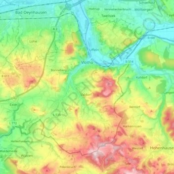
Name: Vlotho topographic map, elevation, terrain.
Location: Vlotho, Kreis Herford, North Rhine-Westphalia, 32602, Germany (52.10149 8.72898 52.19690 8.92672)
Average elevation: 149 m
Minimum elevation: 42 m
Maximum elevation: 333 m
Thank you for supporting this site ❤️
Make a donation
Make a donation
Gear up for your next adventure:
As an Amazon Associate, this site earns from qualifying purchases at no extra cost to you.