
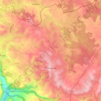
Puylagarde topographic map
Interactive map
Click on the map to display elevation.
About this map
Name: Puylagarde topographic map, elevation, terrain.
Average elevation: 366 m
Minimum elevation: 231 m
Maximum elevation: 425 m
Other topographic maps
Click on a map to view its topography, its elevation and its terrain.
Lacour
Francia > Occitania > Tarn-et-Garonne
Lacour, Castelsarrasin, Tarn-et-Garonne, Occitania, Francia metropolitana, 82190, Francia
Average elevation: 190 m
Lamole
Francia > Occitania > Tarn-et-Garonne > Bioule
Lamole, Bioule, Montauban, Tarn-et-Garonne, Occitania, Francia metropolitana, 82800, Francia
Average elevation: 104 m