
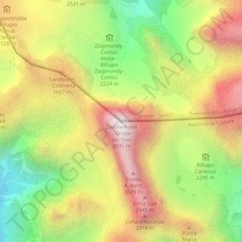
Zwölferkofel - Croda dei Toni topographic map
Interactive map
Click on the map to display elevation.
About this map
Name: Zwölferkofel - Croda dei Toni topographic map, elevation, terrain.
Average elevation: 2,367 m
Minimum elevation: 1,725 m
Maximum elevation: 3,007 m
Other topographic maps
Click on a map to view its topography, its elevation and its terrain.
Misurina
Italy > Veneto > Belluno > Auronzo di Cadore
Misurina, Auronzo di Cadore, Belluno, Veneto, Italy
Average elevation: 1,954 m
Monte Piana
Italy > Veneto > Belluno > Auronzo di Cadore
Monte Piana, Auronzo di Cadore, Belluno, Veneto, Italy
Average elevation: 1,850 m
Tre Cime di Lavaredo - Drei Zinnen
Italy > Veneto > Belluno > Auronzo di Cadore
Tre Cime di Lavaredo - Drei Zinnen, Auronzo di Cadore, Pustertal - Val Pusteria, Belluno, Veneto, 39034, Italy
Average elevation: 2,242 m