
Mammoth topographic map
Interactive map
Click on the map to display elevation.
About this map
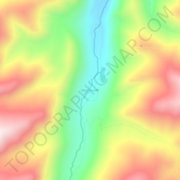
Name: Mammoth topographic map, elevation, terrain.
Location: Mammoth, Madison County, Montana, United States (45.64784 -112.03913 45.68784 -111.99913)
Average elevation: 2,172 m
Minimum elevation: 1,766 m
Maximum elevation: 2,593 m
Other topographic maps
Click on a map to view its topography, its elevation and its terrain.
Twin Bridges
United States > Montana > Madison County
Twin Bridges, Madison County, Montana, United States
Average elevation: 1,414 m
Branham Peaks
United States > Montana > Madison County
Branham Peaks, Madison County, Montana, United States
Average elevation: 2,619 m
Queens Hill
United States > Montana > Madison County
Queens Hill, Madison County, Montana, United States
Average elevation: 2,419 m
Cameron
United States > Montana > Madison County > Cameron
Cameron, Madison County, Montana, United States
Average elevation: 1,642 m