
`Iyadh topographic map
Interactive map
Click on the map to display elevation.
About this map
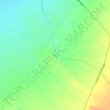
Name: `Iyadh topographic map, elevation, terrain.
Location: `Iyadh, جردان, Gouvernorat de Chabwa, Yémen (14.97395 46.82331 15.01395 46.86331)
Average elevation: 916 m
Minimum elevation: 900 m
Maximum elevation: 936 m
Other topographic maps
Click on a map to view its topography, its elevation and its terrain.
Hamd
Hamd, Bayhan, Gouvernorat de Chabwa, Yémen
Average elevation: 1,206 m
Suwat
Yémen > Gouvernorat de Chabwa > Jawl ash Shaykh > Suwat
Suwat, Jawl ash Shaykh, Mayfah, Gouvernorat de Chabwa, Yémen
Average elevation: 340 m
Al Hajab
Yémen > Gouvernorat de Chabwa > Al Hajab
Al Hajab, Ain, Gouvernorat de Chabwa, Yémen
Average elevation: 1,210 m
An Nuhayy
Yémen > Gouvernorat de Chabwa > An Nuhayy
An Nuhayy, At Talh, Gouvernorat de Chabwa, Yémen
Average elevation: 1,459 m
Al Haram
Yémen > Gouvernorat de Chabwa > Al Haram
Al Haram, Gouvernorat de Chabwa, Yémen
Average elevation: 1,139 m
Al Madinah
Yémen > Gouvernorat de Chabwa > Al Madinah
Al Madinah, Gouvernorat de Chabwa, Yémen
Average elevation: 1,749 m