
Make a donation
Gear up for your next adventure:
As an Amazon Associate, this site earns from qualifying purchases at no extra cost to you.
Freigericht topographic map
Click on the map to display elevation.
Make a donation
Gear up for your next adventure:
As an Amazon Associate, this site earns from qualifying purchases at no extra cost to you.
Freigericht
Freigericht has an elevation of 140 to 371 m in a side valley of the Kinzig river.
Make a donation
Gear up for your next adventure:
As an Amazon Associate, this site earns from qualifying purchases at no extra cost to you.
About this map
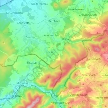
Name: Freigericht topographic map, elevation, terrain.
Location: Freigericht, Main-Kinzig-Kreis, Hesse, 63579, Germany (50.09026 9.06794 50.16324 9.21164)
Average elevation: 224 m
Minimum elevation: 119 m
Maximum elevation: 422 m
Make a donation
Gear up for your next adventure:
As an Amazon Associate, this site earns from qualifying purchases at no extra cost to you.
Other topographic maps
Click on a map to view its topography, its elevation and its terrain.