
Thank you for supporting this site ❤️
Make a donation
Make a donation
Gear up for your next adventure:
As an Amazon Associate, this site earns from qualifying purchases at no extra cost to you.
Rupac topographic map
Click on the map to display elevation.
Thank you for supporting this site ❤️
Make a donation
Make a donation
Gear up for your next adventure:
As an Amazon Associate, this site earns from qualifying purchases at no extra cost to you.
About this map
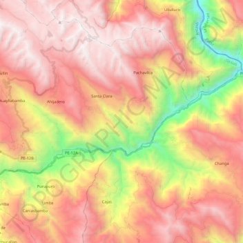
Name: Rupac topographic map, elevation, terrain.
Location: Rupac, Sicsibamba, Province of Sihuas, Ancash, Peru (-8.59834 -77.57810 -8.50755 -77.36565)
Average elevation: 3,277 m
Minimum elevation: 1,685 m
Maximum elevation: 4,399 m
Thank you for supporting this site ❤️
Make a donation
Make a donation
Gear up for your next adventure:
As an Amazon Associate, this site earns from qualifying purchases at no extra cost to you.