
Cantignous topographic map
Interactive map
Click on the map to display elevation.
About this map
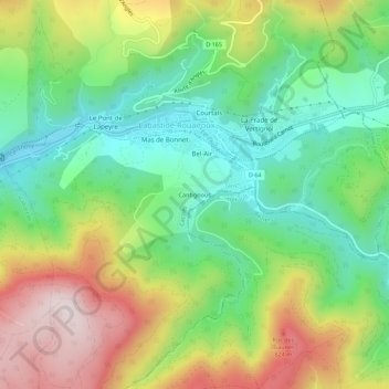
Name: Cantignous topographic map, elevation, terrain.
Average elevation: 576 m
Minimum elevation: 364 m
Maximum elevation: 901 m
Other topographic maps
Click on a map to view its topography, its elevation and its terrain.
Voie Verte Passa Païs
France > Occitanie > Tarn > Labastide-Rouairoux
Voie Verte Passa Païs, Rue de Lafargue, Bel-Air, Fon de Santé, Labastide-Rouairoux, Castres, Tarn, Occitanie, France métropolitaine, 81270, France
Average elevation: 511 m