Geolocate

Inchmurrin topographic map

Click on the map to display elevation.

About this map

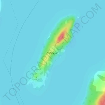
Name: Inchmurrin topographic map, elevation, terrain.

Location: Inchmurrin, West Dunbartonshire, Scotland, G63 0JY, United Kingdom (56.03977 -4.61434 56.05952 -4.58938)

Average elevation: 13 m

Minimum elevation: 7 m

Maximum elevation: 76 m

West Dunbartonshire trails, hiking, mountain biking, running and outdoor activities

Other topographic maps

Click on a map to view its topography, its elevation and its terrain.

Faifley

United Kingdom > Scotland > West Dunbartonshire

Average elevation: 112 m

Milton

United Kingdom > Scotland > West Dunbartonshire

Average elevation: 78 m

Cochno

United Kingdom > Scotland > West Dunbartonshire > Faifley > Cochno

Average elevation: 178 m

Bonhill

United Kingdom > Scotland > West Dunbartonshire

Average elevation: 101 m

Gear up for your next adventure:

👟Women's Trail Running Shoes - Agile footwear for fell running and technical trails
🧢Hiking Hats - Sun and weather protection for outdoor walks
🧺Microfibre Travel Towels - Fast-drying and compact towels for wild swimming and camping
🛰️Handheld GPS Devices - Reliable GPS units for hiking and outdoor navigation
🦯Walking Poles - Supportive poles for long-distance walking

As an Amazon Associate, this site earns from qualifying purchases at no extra cost to you.