
Thank you for supporting this site ❤️
Make a donation
Make a donation
Gear up for your next adventure:
As an Amazon Associate, this site earns from qualifying purchases at no extra cost to you.
Calichal topographic map
Click on the map to display elevation.
Thank you for supporting this site ❤️
Make a donation
Make a donation
Gear up for your next adventure:
As an Amazon Associate, this site earns from qualifying purchases at no extra cost to you.
About this map
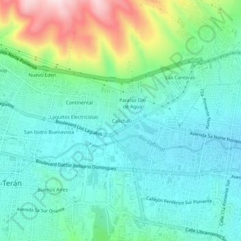
Name: Calichal topographic map, elevation, terrain.
Location: Calichal, Tuxtla Gutiérrez, Chiapas, 29030, Mexico (16.74312 -93.16466 16.78312 -93.12466)
Average elevation: 626 m
Minimum elevation: 526 m
Maximum elevation: 930 m
Thank you for supporting this site ❤️
Make a donation
Make a donation
Gear up for your next adventure:
As an Amazon Associate, this site earns from qualifying purchases at no extra cost to you.