
Make a donation
Gear up for your next adventure:
As an Amazon Associate, this site earns from qualifying purchases at no extra cost to you.
Dargaz County topographic map
Click on the map to display elevation.
Make a donation
Gear up for your next adventure:
As an Amazon Associate, this site earns from qualifying purchases at no extra cost to you.
About this map
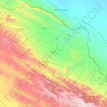
Name: Dargaz County topographic map, elevation, terrain.
Location: Dargaz County, Razavi Khorasan, 94917-39431, Iran (36.97024 58.47688 37.70583 59.43189)
Average elevation: 1,129 m
Minimum elevation: 163 m
Maximum elevation: 3,106 m
Make a donation
Gear up for your next adventure:
As an Amazon Associate, this site earns from qualifying purchases at no extra cost to you.
Other topographic maps
Click on a map to view its topography, its elevation and its terrain.
Make a donation
Gear up for your next adventure:
As an Amazon Associate, this site earns from qualifying purchases at no extra cost to you.
park laleh
Iran > Razavi Khorasan > Chenaran County > شهر چناران > Chenaran
Average elevation: 1,171 m
Make a donation
Gear up for your next adventure:
As an Amazon Associate, this site earns from qualifying purchases at no extra cost to you.