
Jiuzhai Valley National Park topographic map
Interactive map
Click on the map to display elevation.
About this map
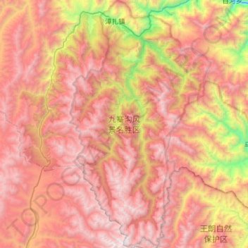
Name: Jiuzhai Valley National Park topographic map, elevation, terrain.
Average elevation: 3,424 m
Minimum elevation: 1,554 m
Maximum elevation: 4,859 m
The Jiuzhaigou valley is part of the Min Mountains on the edge of the Tibetan Plateau and stretches over 72,000 hectares (180,000 acres). It is known for its many multi-level waterfalls, colorful lakes, and snow-capped peaks. Its elevation ranges from 2,000 to 4,500 metres (6,600 to 14,800 ft).
Other topographic maps
Click on a map to view its topography, its elevation and its terrain.
Jiuzhaigou
China > Sichuan > Jiuzhaigou County
Jiuzhaigou, Jiuzhaigou County, Ngawa Tibetan and Qiang Autonomous Prefecture, Sichuan, 623400, China
Average elevation: 2,520 m