
Villa de Leyva topographic map
Interactive map
Click on the map to display elevation.
About this map
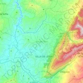
Name: Villa de Leyva topographic map, elevation, terrain.
Location: Villa de Leyva, Ricaurte, Boyacá, Colombia (5.59739 -73.57960 5.72629 -73.42343)
Average elevation: 2,416 m
Minimum elevation: 1,991 m
Maximum elevation: 3,575 m
Located away from major trade routes in a high altitude valley of semi-desert terrain, and with no mineral deposits nearby to exploit, the town has undergone little development in the last 400 years. As a consequence, it is one of the few towns in Colombia to have preserved much of its original colonial style and architecture: the streets and large central plaza are still paved with cobblestones, and many buildings date from the sixteenth century. This has resulted in Villa de Leyva becoming one of Colombia's principal tourist attractions, and it was declared a National Monument on December 17, 1954 to preserve its architecture. The town and the surrounding countryside, which contains several sites of interest, are popular weekend destinations for citizens of Bogota, and attract an increasing number of foreign tourists.
Other topographic maps
Click on a map to view its topography, its elevation and its terrain.
Gachantivá
Gachantivá, Ricaurte, Boyacá, RAP (Especial) Central, Colombia
Average elevation: 2,365 m
Iguaque
Colombia > Boyacá > Villa de Leyva > VILLA DE LEYVA
Iguaque, VILLA DE LEYVA, Villa de Leyva, Ricaurte, Boyacá, RAP (Especial) Central, 154001, Colombia
Average elevation: 2,337 m
Villa de Leyva
Colombia > Boyacá > Villa de Leyva
Villa de Leyva, Boyacá, 15401, Colombia
Average elevation: 2,673 m
Paramo de la Rusia
Paramo de la Rusia, Duitama, Tundama, Boyacá, Colombia
Average elevation: 3,624 m
Guacamayas
Guacamayas, Gutiérrez, Boyacá, 151220, Colombia
Average elevation: 2,641 m
Miraflores
Miraflores, Lengupá, Boyacá, RAP (Especial) Central, Colombia
Average elevation: 1,943 m
Labranzagrande
Labranzagrande, La Libertad, Boyacá, Colombia
Average elevation: 1,978 m
Cerro El Gaital
Cerro El Gaital, Labranzagrande, Boyacá, Colombia
Average elevation: 2,178 m