
Make a donation
Gear up for your next adventure:
As an Amazon Associate, this site earns from qualifying purchases at no extra cost to you.
Patapsco River topographic map
Click on the map to display elevation.
Make a donation
Gear up for your next adventure:
As an Amazon Associate, this site earns from qualifying purchases at no extra cost to you.
Patapsco River
The Patapsco River mainstem begins at the confluence of the North and South Branches, near Marriottsville, approximately 15 miles (24 km) west of downtown Baltimore. The 19.4-mile-long (31.2 km)[1] South Branch rises further west at Parr's Spring, where Howard County, Carroll, Frederick, and Montgomery counties meet. The latter begins at elevation 780 feet (240 m) on Parr's Ridge, just south of Interstate 70 and east of Ridge Road (Highway 27), 2 miles (3 km) south of Mount Airy, Maryland.[1] The South Branch Patapsco River traces the southern boundary of Carroll County and the northern boundary of Howard County. The first land record regarding Parr's Springs dates from 1744, when John Parr laid out a 200 acres (81 ha) tract he called Parr's Range. During the Civil War, Parr's Spring was a stop for the Army of the Potomac's Brig. Gen. David M. Gregg's cavalry, on June 29, 1863, while en route to Gettysburg, Pennsylvania.[9] Parr's Spring was dug to form a 1.75 acres (7,100 m2) pond in the 1950s, filled by seven spring heads that form the headwaters of the South Branch of the Patapsco River.[10]
Make a donation
Gear up for your next adventure:
As an Amazon Associate, this site earns from qualifying purchases at no extra cost to you.
About this map
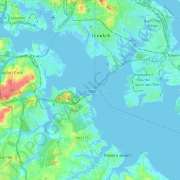
Name: Patapsco River topographic map, elevation, terrain.
Average elevation: 7 m
Minimum elevation: -7 m
Maximum elevation: 51 m
Make a donation
Gear up for your next adventure:
As an Amazon Associate, this site earns from qualifying purchases at no extra cost to you.
Other topographic maps
Click on a map to view its topography, its elevation and its terrain.
Orchard Beach
United States > Maryland > Anne Arundel County > Riviera Beach > Orchard Beach
Average elevation: 6 m