Geolocate

Highland topographic map

Click on the map to display elevation.

About this map

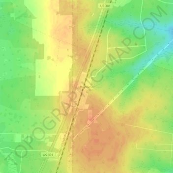
Name: Highland topographic map, elevation, terrain.

Location: Highland, Clay County, Florida, United States (30.09246 -82.06566 30.13246 -82.02566)

Average elevation: 55 m

Minimum elevation: 32 m

Maximum elevation: 69 m

Other topographic maps

Click on a map to view its topography, its elevation and its terrain.

Middleburg

United States > Florida > Clay County

Average elevation: 23 m

Orange Park

United States > Florida > Clay County

Average elevation: 5 m

Penney Farms

United States > Florida > Clay County

Average elevation: 32 m

Crystal Lake

United States > Florida > Clay County

Average elevation: 46 m

Black Creek

United States > Florida > Clay County

Average elevation: 15 m

Lake Asbury

United States > Florida > Clay County > Asbury Lake

Average elevation: 22 m

Asbury Lake

United States > Florida > Clay County

Average elevation: 22 m

Middleburg

United States > Florida > Clay County > Middleburg

Average elevation: 23 m

Orange Park

United States > Florida > Clay County

Average elevation: 5 m

Keystone Heights

United States > Florida > Clay County

Average elevation: 41 m

Middleburg

United States > Florida > Clay County > Middleburg

Average elevation: 19 m

Gear up for your next adventure:

📢Survival Whistles - Essential safety gear for signaling for help in mountain fog
🧺Mesh Stuff Sacks - Breathable storage for wet gear or camp organization
🎒Hiking Daypacks (20L) - Compact backpacks for day trips and technical mountain ascents
📸Action Camera Chest Mounts - Record your ascent following topographic paths hands-free
👕Merino Base Layers - Natural temperature regulation for cold weather hiking and camping

As an Amazon Associate, this site earns from qualifying purchases at no extra cost to you.