
Weitersdorf topographic map
Interactive map
Click on the map to display elevation.
About this map
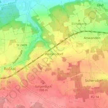
Name: Weitersdorf topographic map, elevation, terrain.
Average elevation: 366 m
Minimum elevation: 304 m
Maximum elevation: 412 m
Other topographic maps
Click on a map to view its topography, its elevation and its terrain.
Großweismannsdorf
Deutschland > Bayern > Landkreis Fürth > Roßtal
Großweismannsdorf, Roßtal, Landkreis Fürth, Bayern, 91189, Deutschland
Average elevation: 389 m